
Additional Information
Category
Edition
16th Edition
Author
B.C. Punnia
Pages
280
Size
22 MB
Published
2005
Get it on
SURVEYING (VOL 1)
By
B.C Punnia
SURVEYING (VOL1) pdf Cover photo
ABOUT SURVEYING (VOL 1):
Surveying is an art of determining relative positions on, above or beneath the surface of the earth by means of direct measurements or indirect measurements of distance, direction and elevation. The application of the survey requires skill along with knowledge of maths, physics and a bit of astronomy.
The knowledge of surveying is beneficial in many phases of engineering, every engineering project requires surveys like establishing of roads, canals, railways, dams etc.
Prior to plans estimates are prepared, boundaries are established and topographies of that area are ascertained. After the plans are made, structures must be staked out on the ground. As the work progresses, lines and grades must be drawn.
NOTE: I have selected a few topics in a view to explain it to some extent showing contents, in order to make it easy to access the pdf which will be attached with the link.
I hope you find it helpful.
This book is shared by HUZAIF JAHANGEER in a view to help the students attain knowledge from this PDF.
All the rights are reserved to the owner of the book as we do not claim the book to be our property.
About Author:
Surveying (VOL 1) Is written by B.C Punnia Formerly, Proff. And head, Deptt. Of civil engineering, and Dean, Faculty of Engineering at M.B.M COLLEGE OF ENGINEERING JODHPUR.
- ASHOK KUMAR JAIN: Director, Arihant Consultants, JODHPUR.
- ARUN KUMAR JAIN: Asst prop. M.B.M ENGINEERING COLLEGE, JODHPUR.
(SIXTEENTH EDITION)
THOROUGHLY REVISED AND ENLARGED AS MENTIONED IN THE PDF
– PLANE SURVEYING (MODULE 1)
Course Outcomes: At the end of the Course, the student will be able to understand:
CO1 :Explain surveying: principles, Classification and linear measurements using chain and tape.
CO2 :Solve various problems related to compass surveying
CO3 :Compute the reduction of levels and prepare contour maps
CO4 :Use theodolite for various applications in construction field and trigonometrical surveying
CO5 :Calculate the areas of irregular boundaries.
CO6 :Calculate earthwork volume and reservoir capacity
Module-2
-COMPASS SURVEYING
Chain surveying can be used when the area to be surveyed is relatively small and is fairly even, but when the area is exceeding the limit, undulated and crowded with many details, triangulation is not possible. In such an area, the method of traversing is adopted.
-Traversing : In Traversing, the framework consists of a number of connected lines. The length is measured by a chain or a tape and the directions measured by angle measuring instruments. In one of the methods, the angle (direction) measuring instrument is the compass. Hence, in compass surveying directions of survey lines are determined with a compass and the length of the lines are measured with a tape or a chain. This process is known as compass traversing.
- Instruments used for direct measurement of directions.
- Surveyor’s compass.
- Prismatic compass.
- Instruments for measuring angles
- Sextant.
- Theodolite.
Also we will study the different meridians and bearings used in surveying.
They are:
- True Meridian
- Magnetic Meridian
- Arbitrary Meridian
- Common systems of notation of bearings:
- Whole circle bearing (WBC) or Azimutal System.
- Quadrantal bearing system (Q B)
- What is a compass? And the temporary adjustments used in compass:
- Fixing
- Centering
- Levelling
- Working of a compass and its parts with diagrams.
- Conversion of WCB to QB
- Magnetic declination and Local attraction
- Elimination of local attraction
MODULE 3:
LEVELLING
- What is levelling
- Principles of levelling
- Terms used in levelling:
Level Surface
Level Line
Horizontal Plane
Horizontal line
Datum
Mean Sea Level
Elevation or Reduced level
Bench Mark (B.M.)
Line of collimation
Height of instrument
Back sight
Fore sight(F.S.)
Intermediate sight.(I.S.)
Change Point (C.P)
- Instruments used in levelling:
Dumpy level
Tilting Level
Wye level
Auto level
- Components of Dumpy level
- Telescope
- Bubble tubes
- Compass
- Vertical spindle
- Tribrach screws
- Foot screws
- Leveling head
- Tripod
- Procedure of Dumpy Level Surveying
Setting up of instrument
Levelling up
Focusing
- Benefits of Dumpy Level Surveying
- Drawbacks of Dumpy Level Surveying
- Classification of Levelling
- Simple Levelling
- Differential Levelling
- Fly Levelling
- Check Levelling
- Profile Levelling
- Cross Levelling
- Reciprocal Levelling
- Precise Levelling
- Trigonometric Levelling
- Barometric Levelling
- Hypsometric Levelling
CONTOURING:
- What is contouring?
- Process of Contouring
- Contour interval and Horizontal Equivalent
- Characteristics of contours
Hills
Depression
Ridge
Cliff
- Process of contouring
- Method of contouring
Direct Method
Indirect method
DISCLAIMERS: PDFMaze also does not own this book/Material, neither was this book created nor scanned. We provided the link to this book which was already available on the internet.
For any queries, It is requested to kindly contact us as we assure you that we will do our best in every way possible.
We do not support pirated content.
You may also like :
Recommended for you

12th Result CBSE May 2023 Full PDF Download Free!
4.8 ★ • 201
Academic & Education Kahoot Tutorial PDF: Everything You Need to Know About Kahoot
4.8 ★ • 227
Academic & Education
Grid Architecture in Cloud Computing PDF (MCA)
★ • 273
Academic & Education Foundation Course on Computers Syllabus PDF (Bca_Imca 1st Semester) Cluster University Srinagar
4.0 ★ • 388
Cluster University Srinagar
Android Studio Tutorial PDF Full Version 2022
4.4 ★ • 453
Academic & Education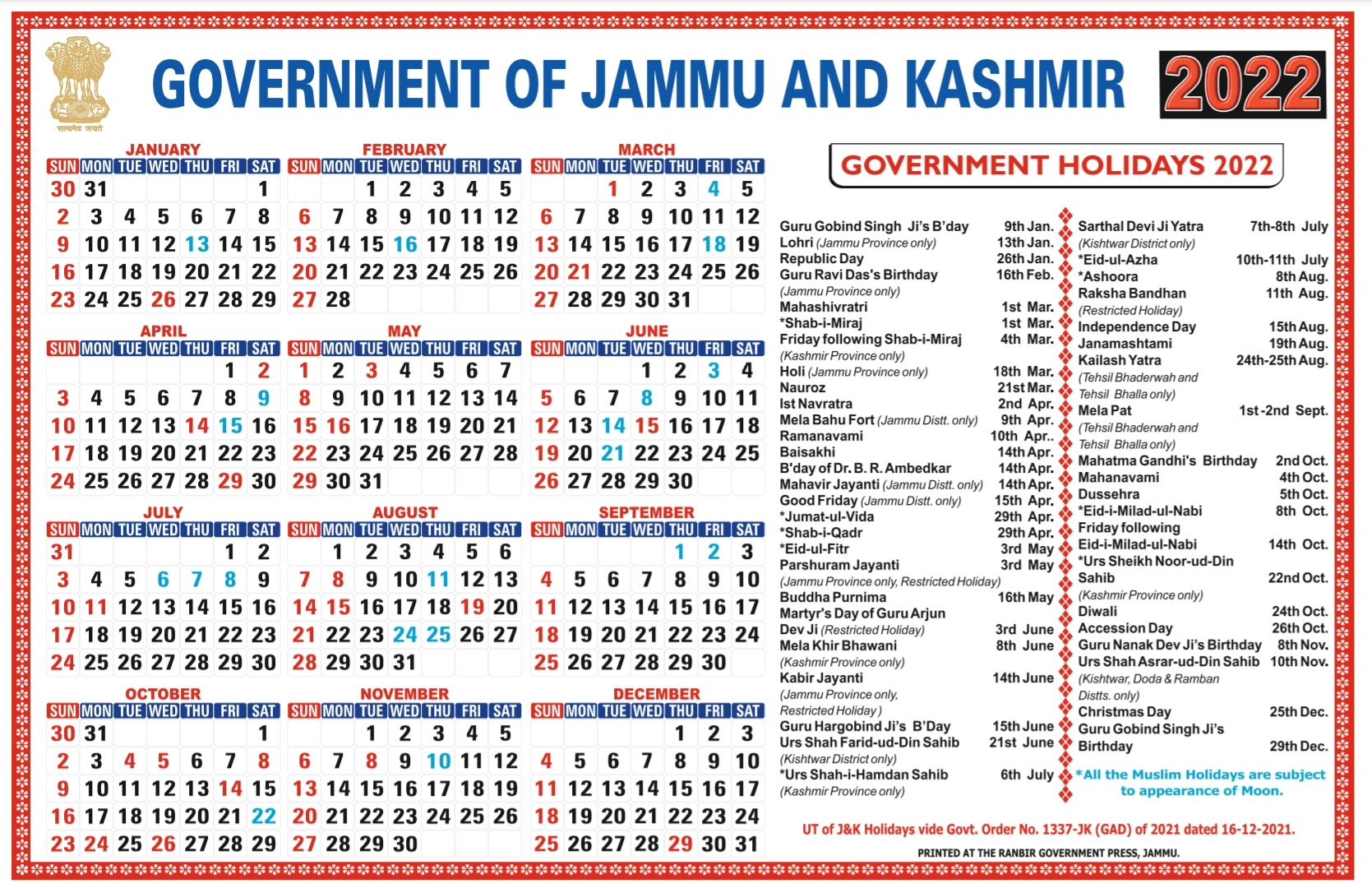
J&K Bank Calendar 2022 pdf Download Free
4.5 ★ • 874
JK Bank SURVEYING (VOL 1) By B.C Punnia 2005
3.5 ★ • 621
Engineering
Building Materials Construction PDF-2019 (Drive)
3.7 ★ • 645
EngineeringYou may also like
Android Studio Tutorial PDF Full Version 2022
4.4 ★ • 453
Academic & Education Foundation Course on Computers Syllabus PDF (Bca_Imca 1st Semester) Cluster University Srinagar
4.0 ★ • 388
Cluster University Srinagar
Out Of The Abyss PDF 2015 (Drive)
4.6 ★ • 743
DnD
Chinua Achebe Things Fall Apart Book PDF Free Download 1958-(Drive)
4.6 ★ • 392
novel
D&D Hoard Of The Dragon Queen PDF 2014(Drive)
4.5 ★ • 802
DnD
D&D Tasha’s Cauldron of Everything PDF Free Download -(Drive)
4.8 ★ • 487
DnD
Rich Dad Poor Dad(2014)
4.4 ★ • 726
Editor's Choice
The Four Agreements 1997 Book PDF Free Download (Drive)
4.4 ★ • 461
Personal Growth
J&K Bank Calendar 2024 PDF Download Free
4.9 ★ • 113
JK Bank
A Good Man Is Hard to Find Summary PDF by Flannery O’Connor (Drive)
4.4 ★ • 867
Drama
JK bank calendar 2021 pdf download
4.4 ★ • 659
JK Bank J&K Bank Calendar 2022 pdf Download Free
4.5 ★ • 874
JK Bank
Download 15th August 2022 Independence Day Speech In Hindi & English PDF
2022

Lost Mines Of Phandelver PDF (2014)-Download
2014

The 5 Second Rule: Transform your Life, Work, and Confidence with Everyday Courage(2017)
2017

You Are a Badass: How to Stop Doubting Your Greatness and Start Living an Awesome Life(2011)
2015

d&d Storm King’s Thunder PDF 2016 Free Download-(Drive) – Updated 2023
2016

Boundaries: When to Say Yes, How to Say No to Take Control of Your Life(2001)
2001
PDF'S
Comments